

-
USD
-
INR

USD
INR
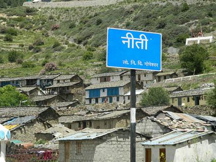
The Niti Valley is situated to the hinterland of Joshimath. Niti, located at an elevation of 3,600 m, is the most important village of the valley. To the north of this village is the Niti Pass (5,800 m) leading to southern Tibet. All kind of traditional rituals are performed during this period of stay by the community.
In the hills of Garhwal, the two major passes to Tibet (China) are Niti and Mana. These two passes were used by traders of Tibet and India before 1962, which were closed later. These two beautiful valleys were developed due to trading and fertile atmosphere, which are at an elevation from 3000 m to 5800 m.
The community is a group of people living in the trans-Himalayan regions of India - Tibet border in Garhwali hills. Tibet is known as Bhot. Being connected with Tibet, the community of Niti and Mana valleys is officially named as Bhotia. The community is also referred as Rongpa in the valley. The word “Rongpa” derives from the words "Rung" and “Pa”. Where Rung means Valley and Pa means inhabitants. Bhotia community inhabit in the valleys (Niti and Mana) of District Chamoli of Uttarakhan
These valleys are surrounded by many beautiful snow covered mountains, trees, forests and rivers. Many small villages and temples can be seen in these mountains range. The region receives heavy snowfall. The inhabitants of the valley move from their alternative villages (which are in the lower range of Himalayas) to the valley during summer and stay in the valley from March to jun.
The best time to visit April to June.
By Air
Jolly Grant Airport, Dehradun (362 kms).
By Train
Rishikesh railway station (346 kms).
Shopping in Niti is an absolute delight. After a day of some fine sightseeing and other activities, it’s but natural to indulge in a little bit of shopping. Explore the shops and the markets of Niti to find the most famous of its offerings. Buy souvenirs and other gifts for yourself and your friends and families – after all shopping in Niti
![]()
![]()